-
Competition for the Reconstruction of Destroyed Palestinian Villages "Year 6" :
/images/vid.png) Event video:
Event video:
-
The Winners of the Competition for the Reconstruction of Destroyed Palestinian Villages "Year 6" are:
First prizes:
This 6
th year, the competition produced more innovative designs. Two projects were so good that they were both awarded the First Prize. The monetary value was split between them. These projects will be shown and discussed publicly with the people of these two depopulated villages, now refugees in refugee camps. The Second Prize was not offered this year. The Third Prize and two Commendations were awarded. All winners received Certificates.
The winner from the Al Balqa Applied University (BAU01):
- Majd Mohamad Abdel Kareem Jahshan
- Donia Mohamad Yassin Alsalman
- Sajeda Abdullah Awad Alnaqrooz
Project: Suba Village - Jerusalem District
Project description:
The project is the reconstruction of the village of Suba, one of the villages of Palestine that was destroyed in 1948, so that it becomes suitable for receiving its people and making them able to overcome the impacts of the occupation and to emphasize the memory of the village in the past and its importance.
The chosen village is Suba, it was chosen because of its unique strategic location, as it is based on four adjacent hills and is considered the defense area of Jerusalem from the western side. Some of its houses are in almost good condition, so that the documentation and preservation process is easy.
Suba is a village with an area of 4,103 dunums, located 10 km west of Jerusalem.
The village is rich with resources, when these resources are properly utilized, it will reach a state of self-sufficiency so that it becomes for its residents something called (Dar al-Maqamah) One of the names of Paradise mentioned in the Qur’an once. Paradise is called Dar al-Maqamah, because its people reside in it and do not leave it, and their situation there does not change due to the abundance of its bounties, the succession of its joys, and the rarity of its difficulties. And we seek in this design to make SUBA like that for its inhabitants.
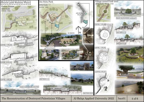
And after many interviews with the people of the village, we got a good set of stories in places that have a high symbolic value in the hearts of the people of the village. In order to remain this memory in the minds of generations upon return, a path has been established linking all that places that have high symbolism, this path is named “the last return”. So return is the dream of every Palestinian who forced displacement from his home.
We have three targets’ users: The people of the village who were displaced from it since 1948, and their children and grandchildren, The Palestinian visitors from all over the town and Tourists from outside Palestine to get acquainted with the story of this village.
Therefore, we’ve designed:

1) a visitor center to welcome them, which is the first station of the path to acquaint visitors with the history of the village and the history of Palestine as well, as well as exhibitions of the crafts that the people of the village used to work in. About the building that is underground from the beginning side in order to return the visitors to their origin and stir their intimate feelings with their land.
2)Suba spring is the main permanent water source that the people of the village used to rely on in their daily lives and irrigate their crops, which is the second station where is a memorial park has been established. Al Ain Tunnel has been expanded and is able to receive visitors.
In addition to preserving and protecting the rest of the traditional water sources in the village, such as wells, springs and ponds, at least as a historical reference.
3) Crusader roof under its men had rest in the past, it was destroyed, Memory columns are designed in this place from the remnants of excessive destruction in the old village at the top, as if these stones narrate what happened to them, as the rock feel miss also.
4) The perennial oak tree: In the old days, the residents elect their mayors and receive the owners and officials there, and this place was chosen where the village council is designed.
5) Al-mogtasal olive tree: And it is a perennial tree that also has a cemetery for the people of the village and a group of graves for the righteous saints.
6)The shrine of Ibrahim Al-Adhami has been restored, while preserving the effect of the destruction clear so that the image is rooted in the memory of everyone who visits it. And it remained as a shrine.
7)Beit Halima is the only house in the village that has a woman’s name, and to emphasize the women’s role, its use has been changed to a women’s association.
8) The old village (museum):
The old buildings were divided into two parts, inside and outside the village wall
Outside the wall: restoration with adaptive reuse, the new function “hotel suites”
Inside the wall: we have classified houses according to the extent of damage then we put a strategy for restoration as:
*Building part of the completely demolished houses, as it was previously in terms of construction and materials.
* Expand buildings with new outlines to suit the function.
* Not building a part of what was previously demolished and making it visible
* In the restoration, we’ve used materials different from the original materials, so that the impact of the occupation remains clear in the memory.
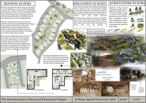
To emphasize memory, the way to neighborhoods is by going through the past to reach the present. So, the location of them selected based on principles of organic planning and sustainability and making sure to reduce the damage to the cultivated lands by building on wild lands and reducing the consumption of land in housing as much as possible. Also, the green roof system has been adopted.
Healthcare: Providing the village with an emergency center with a group of clinics
Education: Just as the only school in the village was destroyed before it began its work, an educational complex was designed within the service diameter of the village as a whole, where every person has the right to obtain all levels of education, basic, preparatory, secondary and even craft education.
Industry: Taking advantage of the factories left by the occupation and keeping them away from the places of residence as they are prefabricated buildings so that they can be moved.
Roads and transportation: A network of roads in harmony with the topography, as all places are served by transportation and roads, and the complete street system was used, so that the village become friendly to pedestrians and bicycles.
Cultivation: using system of agricultural terraces that simulates the traditional terraces, which are used as a public green space, a source of food, a water management system and an energy house.
***********************************************************************************************************************************
The winner from German Jordanian University (GJU01):
- Nayrouz Ali
Project: Saffuriya Village - Nazareth District
Project description:
On 20 February 1949, the Israeli moshav of Tzippori was founded southeast of the older village. The pomegranate and olive trees were replaced with crops for cattle fodder.
Analysis and Conclusions
The Forest:
Planting forests in the sites of abandoned villages is a method followed by the occupation and actually aims to:
-Cover war crimes against demolished and depopulated villages
- Ensure that the people of the villages will not return and the construction of new homes on the site.
Pine trees are specially selected so that:
- They are not fruitful trees and are frequented by the village's refugees
- They create a link between the European settlers and the land
The Forest takes a huge part of the physical area of the site, it cannot be ignored nor pulled out, however, it is important to acknowledge that although it a fundamental natural and aesthetic element, in this specific context it used as a tool to practice ethnic cleansing of the Palestinians.
The Archeological remains:
The site is a time witness that has remains of most of the historical periods the region has been through, being located on top of the hill, and in a small area makes the site a very special one.
The Missing Layer:
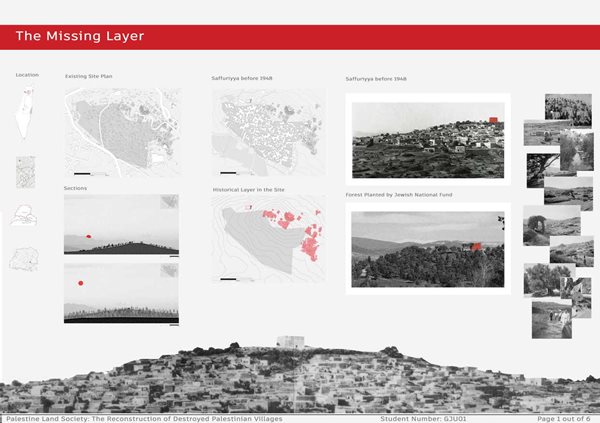
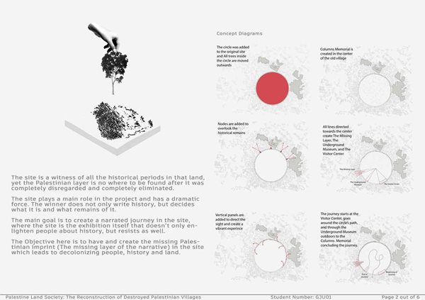
The site is a witness of all the historical periods in that land, yet the Palestinian layer is no where to be found after it was completely disregarded and completely eliminated.
Project Goals, Objectives and Concept:
The site plays a main role in the project and has a dramatic force. The winner does not only write history, but decides what it is and what remains of it.
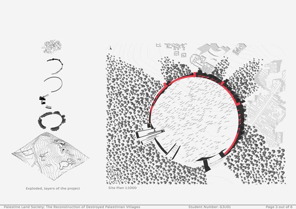
The main goal is to create a narrated journey in the site, where the site is the exhibition itself that doesn’t only enlighten people about history, but resists as well.
The Objective here is to have and create the missing Palestinian imprint (The missing layer of the narrative) in the site which leads to decolonizing people, history and land.
Design Statement:
Based on the site analysis conclusion, the project is an open air museum that connects the archeological historical remains with what's most important part; The Missing Layer The people who lived, live and continue to live there no matter who had a power.
The Site is telling this story itself, the project is a translation for everything Saffuriyya stands for.
Suggested Program, Activities and Typologies:
It is important to acknowledge that in that specific site, there are different typologies of “exhibits” that require a specific treatment for each. There are three main layers to deal with, the first has to be the archeological park, it surely has a strong impact on the project narrative, however, the decision was for it to be just a stop and a part of the project that helps to build the experience, but isn’t the main force driver of the project.
The second one is the forest that represents a huge challenge, where it can be treated as a normal aesthetic and natural element, and another approach to treat it aggressively as a tool to depopulate and ethnically cleanse Palestinians.
Lastly, “The Missing Layer”, the only architecture that is going to be added, reflecting the hidden truth of the site.
The outdoor museum journey will be mostly in a trail that connects all these layers together. The decision was to go through the archeological park, forest and then “The Missing Layer” in order to offer what is apparent and then move to the crime done to people and history.
Some nodes of the Missing Layer were added in order to provide a perspective of the Village, and focusing on the Village as a representation for all depopulated Palestinian villages.
The Program has a Visitor Center with its logistics as a start for the journey, forest and archeological layer are stops and a part of the bigger picture, after comes “The Missing Layer” with its multiple nodes and functions, and the journey is ended in a specific and dramatic end point.
Total built up area would be huge compared to the huge site taken, firstly because of the decision of making it an open air museum, secondly the existence of the forest limits wide mass buildings.
***********************************************************************************************************************************
The third prize:
The winner from the University of Palestine (UPG01):
- Saji Mohammed Jihad Ali Hamed (Team Leader)
- Bayan Emad Ibrahim Rosros
- Eman Adnan AbdAlKareem Baker
- Samir Mazen Ghazi Abu Khattab
Project: Al Lajjun Village - Jenin District
Project description:
Reconstruction of the village Al-Lajjun - Parameters
Welcome to the world of Params
Concept:
بالعربية ) ُمتَغيّرات( Parameters
Everything revolves in this astronomy, everything that moves in the world is made up of Parameters.
Nothing in the universe is constant, everything is constantly changing.
We believe in the idea of parameters and everything is variable. We have a great belief that the current situation will change and occupation will one day disappear and the sun of freedom will shine on our country and our villages from which we were forcibly abandoned and from this belief we proceed.
We have applied the parametric design method to all parts of the project while preserving the original identity of the village.
How can we apply the Concept?
We first studied the planning of the village streets, so we adopted the current planning without any change and kept the places (Mosques - Café - schools – houses); in order to preserve as much as possible, the coordinates of the places that were located in the village.
.jpg?width=350&height=495)
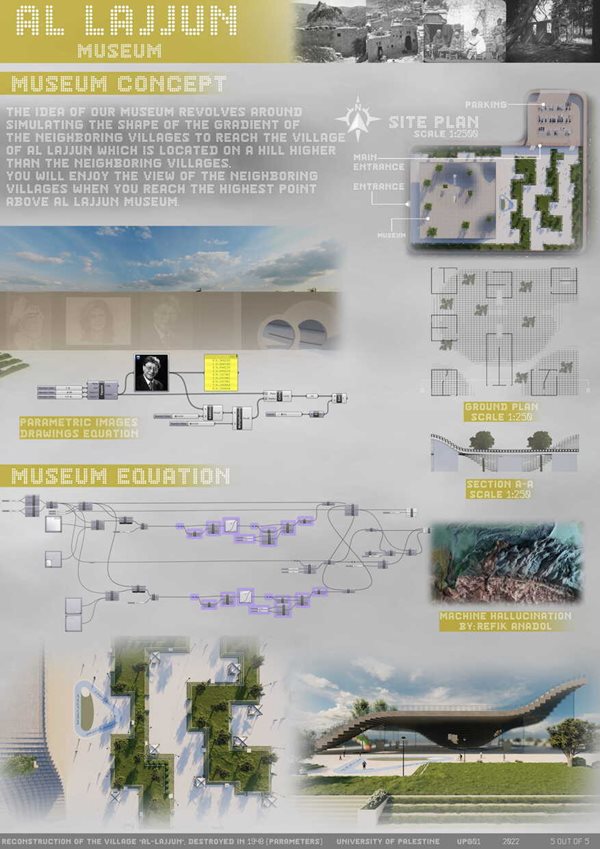
We replaced the old architectural elements such as mashrabiyas - arcades and re-designed them parametrically while maintaining the same features and functions offered by both mashrabiyas and arcades.
We replaced the method of drawing on the walls of the museum by making parametric drawings of the most prominent Palestinian figures (Mahmoud Darwish - Shereen Abu Aqleh - Yasser Arafat).
We replaced the display inside the museum, instead of displaying pictures of the village and the Nakba in 1948 as a kind of perpetuating the difficult memories experienced by the villagers. We collected the pictures and made a "Machines Hallucination" video and presented them in a modern and advanced way inside the museum (as shown in the video, we attached an example work by Refik Anadol).
We don't just design for previous generations! We design for new generations that have the right to keep pace with the technological development that is happening around the world.
With these serious and steady steps in design, we made the old generation feel nostalgic and say: “Yes! This is Al-Lajjun from which we were forcibly displaced in 1948".
Also, if the new generation looks at the village, it will say that it keeps pace with development.
Principles:
Not only did we adopt parametric design as the sole design principle; but it was also supported by environmental design.
We did complete environmental analysis of the residential homes in the village and came up with absolutely amazing results.
We have provided natural lighting inside the house throughout the day through the Solar Tubes on the rooftops, using breakers and light shelves to reduce glare in the homes. And thus, reducing energy consumption in the house and this results in reducing the annual percentage of carbon emissions from the building.
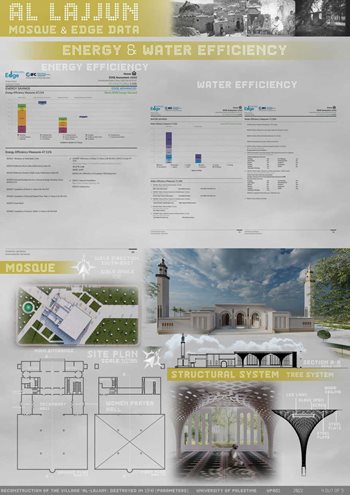
We have done full studies on the famous and accredited environmental analysis program from LEED & BREAM (ClimateStudio), and we have also completed some studies on Energy and Water Efficiency on EDGE it's also accredited by LEED.
All results of studies (sDA, ASE, Glare, Illumination, Energy & Water Efficiency) are attached in the A1 Sheets.
We strongly believe that technology is here for our convenience so we used technology in a very smart way in our project and it was a very difficult challenge to design something that would serve two different generations. But this thing is not impossible! We really did it.
All this and more inside our project!
***********************************************************************************************************************************
Commendation 1:
The winner from German Jordanian University (GJU02):
Ala' Amro
Project: Bayt Jibrin Village - Acre District
Project Description:
INTRODUCTION
After the demise of the Israeli occupation, my project will be.
The choice of Al-jurah for me was for both it’s location in the old province of Gaza, “The biggest open prison in the world” , and for it’s location on the sea. The loss of Palestinian land is also the loss of the SEA. The story of the Palestinian with his/her sea is a bleeding one, and “We still long for our sea” . This project then
will tend to bring back the sea life to the Palestinians, as well as it’s sea culture, the tangible and the intangible one with a romantic/touristic approach.“I AM THE SEA”.
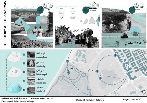
THE STORY:
The NAKBA 1948, the year al-jurah was occupied in, is the benchmark when telling the story of al-jurah, looking at it’s story before during and after the Nakba will be the core to my approach in analysis, concept, and design.
Before the Nakba:
The first thing one notices when they see al-jurah is the sea, al-jura was one of the main lords of the Mediterranean sea, they built on the sea unlike the other Palestinian shore villages. Their main income was from fishing and so al-jura was very famous for it’s sea craftmanship teaching Gaza ship-making, their art of fishing and their songs. One used to hear about al-jura from “4th of Ayyub” event. Everyone used to know al�jura because of it. It’s one of the only two events in Palestine back then, and this one was for celebrating the seas. Al-jura was an icon of the sea with it’s unique relationship with the sea.

Analysis:
What to preserve after roads, morphology and typology
analysis:
1. The old remaining fisherman’s road
2. The remaining old well and house on site
3. The typography to the sea.
The Nakba:
15-10-1948 : The date of the Israeli attack on the village, 70 people were killed on spot.
05-11-1948: the date when the village was officially announced as occupied.
Palestine shrank to what is today known as the west bank and Gaza only and the rest became occupied land territories. Al-jurah was in Gaza province, today in ashkelon. Villagers thought it’s just few days only, they fled through the sea to other lands, so for them the sea was their savior too. This marks the date the Palestinians lost their SEA.
Analysis:
What to consider from the new roads, accessibility and landmarks:
1. High Ashkelon settlement acts as an expelling edge to the site
2. Site is highly accessible.
3. Ashkelon national park with the oldest gate in the world.
After the Nakba:
After the Nakba is (today), it’s what’s between the lines of the past and today. Between them today is the very strong nostalgia of the Palestinian with the SEA. It’s the stories of our grandparents fishing at the shores of Palestine, it’s the sea smell and sound in our poems, it’s the blue in our arts, and it’s the ship adventures in
our songs, this is the layer in between... It’s the Palestinian layer that was erased.
Analysis:
After layering the old and new maps together, these forces will be taken further
THE CONCEPT:
“ Celebrating the SEA after a very long deprivation by reviving the Palestinian sea event 4th of Ayyub”:
This is an event said to have been introduced by the khalifah Salah-al-Deen, it’s a once a year event that brought people together from all over Palestine and sometimes the Arab world to come and enjoy the sea.
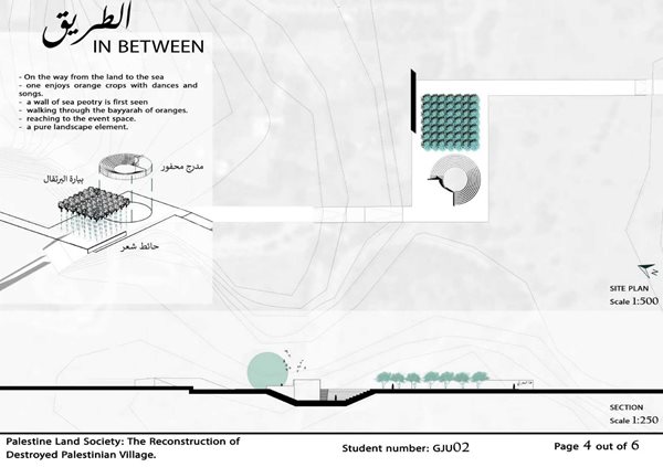
Tracing back this event it used to last three days, starting from the village where they spent the time with the villagers eating talking and sleeping at their places, then to the planted fields of al-jurah enjoying the crops with the singing and dancing, then lastly to the peak of celebration THE SEA, enjoying all it’s cultural forms
(ship making and surfing, swimming, crafts and enjoying the view). Therefore my project was then divided into 3 nodes with “the meeting of two paths making a project (a change in direction)”, the land , the sea and between them.